Connect to web services for live, updated data & information.
For use in your own applications or databases, you may connect to ARMAP’s suite of web services — data streams direct from ARMAP’s servers. They can be opened in a variety of data management systems, GIS applications, and other software packages. They allow users and organizations quick access to comprehensive, remotely updated data, including information on field-based research, a base map, other Arctic map layers, and more. The web services are available in a variety of open, community-adopted formats and standards to promote cross-platform data sharing and re-use.
See also:
- The AOV Web Services page, with related services.
- The AOV Guide to Interoperability, with documentation about the “Project-Data Life Cycle”, examples of implementing hierarchical and distributed metadata web services with ISO, data dictionaries, and more.
Field Research Projects REST
One of ARMAP’s most requested features is the ISO REST service for Field Research Project Locations, which allows you to access metadata records and customize parameters for a permanent URL.
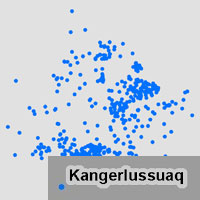
Field Research Project Locations
 This web service contains the locations and high-level project information for field-based Arctic research projects funded by the National Science Foundation (NSF) since 1999. It also includes projects from other agencies (such as NOAA and NASA) that receive logistical support from NSF. Database fields include investigator name, project title, discipline, year, funding agency, a description, and more. The information is pulled from the Munnin logistics database, which is maintained by Battelle Arctic Research Operations. Project records conform to an interagency project-tracking metadata standard developed in collaboration with the Alaska Data Integration Work Group (ADIwg). Comparable project-level web services might be available direct from other agencies or organizations shown in the ARMAP Viewer.
For ArcGIS Users, copy and paste into your application: http://arcticgeoservices.org/arcgis/services/public/Arctic_Field_Research_Projects/MapServer/WMSServer
For Other Users, copy and paste into your application: http://arcticgeoservices.org/arcgis/services/public/Arctic_Field_Research_Projects/MapServer/WMSServer?request=GetCapabilities&service=WMS
For ArcGIS Users, copy and paste into your application: http://arcticgeoservices.org/arcgis/services/public/Arctic_Field_Research_Projects/MapServer/WFSServer
For Other Users, copy and paste into your application: http://arcticgeoservices.org/arcgis/services/public/Arctic_Field_Research_Projects/MapServer/WFSServer?request=GetCapabilities&service=WFS
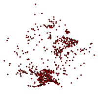
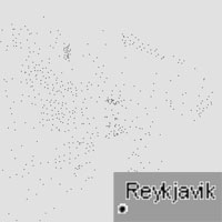
Location Placenames
 This web service contains field research location names (with location and region) for the Arctic region (45 degrees North latitude and above). The information was derived from the Muninn logistics database maintained by Battelle Arctic Research Operations. For logistics planners and others, this web service may be useful as a placename gazetteer.
For ArcGIS Users, copy and paste into your application: http://arcticgeoservices.org/arcgis/services/public/Arctic_Field_Research_Site_Names/MapServer/WMSServer
For Other Users, copy and paste into your application: http://arcticgeoservices.org/arcgis/services/public/Arctic_Field_Research_Site_Names/MapServer/WMSServer?request=GetCapabilities&service=WMS
For ArcGIS and Quantum GIS Users, copy and paste into your application: http://arcticgeoservices.org/arcgis/services/public/Arctic_Field_Research_Site_Names/MapServer/WFSServer
For Other Users, copy and paste into your application: http://arcticgeoservices.org/arcgis/services/public/Arctic_Field_Research_Site_Names/MapServer/WFSServer?request=GetCapabilities&service=WFS
Arctic Base Map
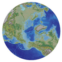 This web service is a base map for the Circumarctic, showing elevation and bathymetry (through use of color ramps plus shaded relief). The map was created from: 1) the Global 30 Arc-Second Elevation dataset (GTOPO30 from the USGS); and 2) the 2-Minute Gridded Global Relief Data (ETOPO2, from NOAA). As for the other ARMAP web services, this base map supports numerous map projections, but is currently optimized for performance (cached) for the North Pole LAEA Alaska projection (EPSG 3572).
For ArcGIS Users, copy and paste into your application: http://arcticgeoservices.org/arcgis/services/public/Arctic_Base_Map/MapServer/WMSServer
For Other Users, copy and paste into your application: http://arcticgeoservices.org/arcgis/services/public/Arctic_Base_Map/MapServer/WMSServer?request=GetCapabilities&service=WMS
Arctic Countries
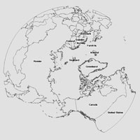 This web service is a map layer showing the boundaries for Arctic countries as they existed in 2005 for areas north of 35 degrees latitude (derived from ESRI Data & Maps).
For ArcGIS Users, copy and paste into your application: http://arcticgeoservices.org/arcgis/services/public/Arctic_Countries/MapServer/WMSServer
For Other Users, copy and paste into your application: http://arcticgeoservices.org/arcgis/services/public/Arctic_Countries/MapServer/WMSServer?request=GetCapabilities&service=WMS
For ArcGIS and Quantum GIS Users, copy and paste into your application: http://arcticgeoservices.org/arcgis/services/public/Arctic_Countries/MapServer/WFSServer
For Other Users, copy and paste into your application: http://arcticgeoservices.org/arcgis/services/public/Arctic_Countries/MapServer/WFSServer?request=GetCapabilities&service=WFS
Arctic World Cities
 This web service is a map layer showing the locations of cities for the world, including: national capitals, provincial capitals, major population centers, and landmark cities, as they existed in 2005 for areas north of 35 degrees latitude (derived from ESRI Data & Maps).
For ArcGIS Users, copy and paste into your application: http://arcticgeoservices.org/arcgis/services/public/Places_World_Cities/MapServer/WMSServer
For Other Users, copy and paste into your application: http://arcticgeoservices.org/arcgis/services/public/Places_World_Cities/MapServer/WMSServer?request=GetCapabilities&service=WMS
For ArcGIS and Quantum GIS Users, copy and paste into your application: http://arcticgeoservices.org/arcgis/services/public/Places_World_Cities/MapServer/WFSServer
For Other Users, copy and paste into your application: http://arcticgeoservices.org/arcgis/services/public/Places_World_Cities/MapServer/WFSServer?request=GetCapabilities&service=WFS
Map Projections
ARMAP’s web mapping applications and web services utilitze variations of the “North Pole Lambert Azimuthal Equal Area” map projection (with the WGS84 datum). These projections are often used by various organizations to view the globe from a polar perspective. Click on the EPSG codes below for detailed parameters.
Projection |
EPSG Code
|
Coordinate System Name |
| LAEA Alaska | WGS 1984 / North Pole LAEA Alaska | |
| LAEA Bering Sea | WGS 1984 / North Pole LAEA Bering Sea | |
| LAEA Canada | WGS 1984 / North Pole LAEA Canada | |
| LAEA North Atlantic / Greenland | WGS 1984 / North Pole LAEA Atlantic | |
| LAEA Northern Europe | WGS 1984 / North Pole LAEA Europe | |
| LAEA Russia | WGS 1984 / North Pole LAEA Russia |
These web services support numerous map projections, but are currently optimized for performance (in other words, “cached”) for the North Pole LAEA Alaska projection (EPSG3572). If you would like us to add additional map projections to our capabilities files, please contact us.
ARMAP is committed to best practices for data sharing, and will continue to make data available in a variety of services and formats to address the needs of different user communities.